The Role of UAVs in Environmental Monitoring and Conservation Efforts
Drones, or UAVs, have become handy environmental monitoring and conservation tools. This is thanks to their ability to carry various sensors and access hard-to-reach areas, their accessibility and real-time data transmission capabilities have seen multiple companies and stakeholders find use cases for them in protecting and managing natural resources. Let’s look at how UAS systems have become helpful in these activities.
1. Wildlife Monitoring
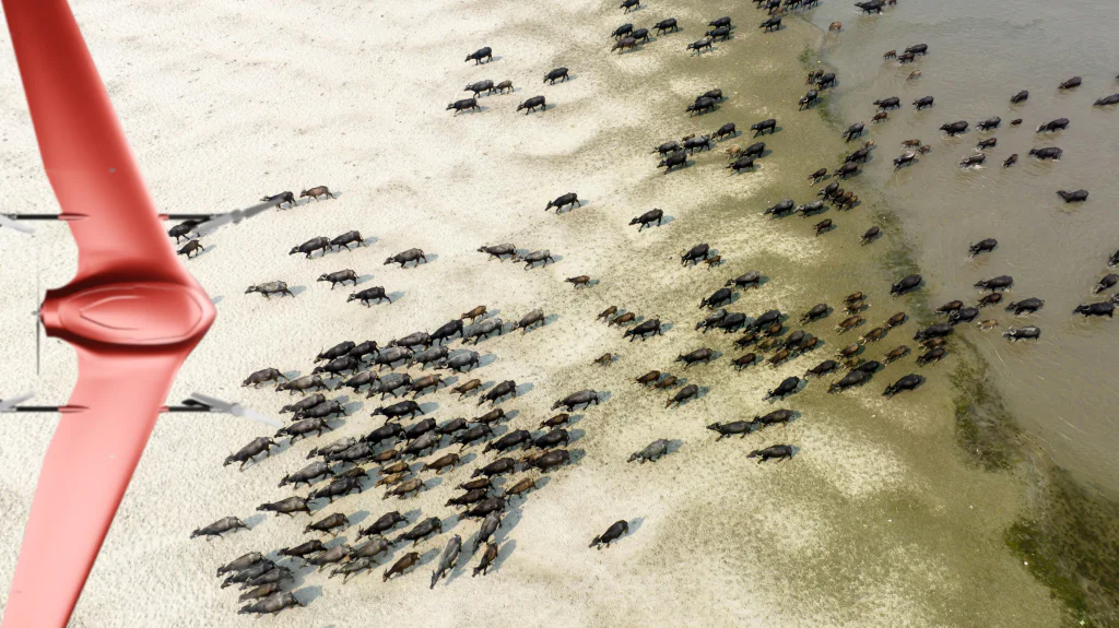
Drones have become useful in monitoring wildlife thanks to their ability to access hard-to-reach areas. Observing animals’ behavior from afar and predicting their movement is now possible.
This also helps us better understand them by understanding their migration and mating patterns and the challenges they face, especially the challenges of endangered species, which contribute significantly to their conservation. Companies like Wildlife Drones are using drones and radio technology to monitor birds’ and mammals’ behavior.
High-quality cameras also allow users to conduct animal censuses and map animals’ habitats and how they are changing. Even when there is dense vegetation or minimal lighting, users can use thermal cameras to monitor wildlife. In areas where there is a risk of encroachment or poaching of wildlife, drones have become useful surveillance tools, giving the ground teams an aerial advantage.
2. Habitat Conservation
Drones can be used for surveying and mapping over a set period to determine how the habitat changes over time. This is thanks to their ability to take high-quality geo-tagged images, which can then be stitched together to form detailed orthomosaics and 3D models. For instance, Carrot Drone Services used drones to map how human traffic affected animal’s habitats by mapping every six months.
3. Vegetation and Forest Management
There are various ways drones are useful in vegetation and forest management. These include;
Vegetation Health Monitoring
Drones with multispectral and hyperspectral sensors can help detect the health and composition of vegetation and soils, making it easier for conservationists to determine what exactly needs to be done. Companies like GlobHe are making such drone data available to users by connecting users to drone pilots and service providers, making it even easier for people who lack the resources to collect the data themselves.
Reafforestation Efforts
According to the FAO, deforestation is on the rise in most of the largest forests worldwide. Much of it is due to human activities, but wildfires and climate change have also contributed. Luckily, drones can help restore some of the lost forests. Much larger drones with tanks that can carry up to 40 kg of weight are being used to plant trees around the world.
This method is faster and allows people to restore forests in areas that cannot be reached by walking or using vehicles. Before planting, conservationists can leverage the drone’s power of data collection to collect data like topography, soil health, slope, biodiversity, etc.
This helps maximize the available land while avoiding areas where trees wouldn’t grow, such as cliffs or water bodies. A good example of a company doing this is Dendra, which has come up with innovative ways to leverage drone technology and AI to plant forests at a much faster rate.
4. Climate Change Research
Drones can help generate more insights into climate change by tracking glacier melting and movement. Recently, drones have also been helpful in mapping forest and canopy cover and estimating how much carbon they absorb, which helps conservationists determine how much forest cover is needed to slow carbon dioxide accumulation in the atmosphere.
5. Marine Conservation and Restoration
UAVs are also helpful in marine and coastal management in several ways. They can help detect pollution by looking for oil spills, plastics, and other items that should not be in the marine environment. Drones with multispectral sensors can help monitor coral reefs and detect degradation or bleaching events.
Conservationists or security agencies can use drones to monitor illegal fishing, marine land encroachment, and other activities that endanger marine environments. UAVs are also being used to restore marine ecosystems, like in reforestation. For instance, Delta Blue Carbon, in partnership with Inverto Earth, is embarking on one of the largest mangrove restoration projects by leveraging drones.
6. Disaster Response
When disasters strike, UAVs can quickly assess damage to the environment and help devise solutions for resource allocation and restoration.
Conclusion
It’s great to see how UAVs are helping with environmental monitoring and conservation. By providing precise, real-time data in a cost-effective model, drones are helping with wildlife monitoring, habitat conservation, forest management and restoration, marine conservation, climate change research, and disaster response.