Top 5 Drone Software Tools for Surveying Large Infrastructure Projects
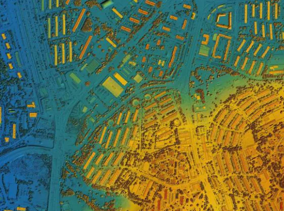
Surveying vast areas can be difficult, but with the latest advancements in software technology and AI, it’s now manageable. Such software eases mapping and monitoring of an area by allowing for accurate data collection and analysis. What’s more, you can select an ideal one for your project depending on the features it has.
The top five drone software tools for surveying large infrastructure projects include Agisoft Metashape, Pix4D, FlyPix AI, SimActive, and DroneDeploy. These tools streamline operations, enhance precision, and reduce costs.
Read on as we explore the leading drone surveying software tools so that you can identify the solution that best suits your needs.
Which Are the Top 5 Drone Software Tools for Surveying Large Infrastructure Projects?
The ultimate drone software tools for aerial surveying include the following:
Agisoft Metashape
The Agisoft LLC photogrammetry solution is an advanced stand-alone software designed to generate 3D spatial data from still images.
Metashape creates professional-grade 3D content based on the latest multi-view 3D reconstruction technology. It operates efficiently under controlled and uncontrolled conditions and works with random images.
Thus, you can take photos from various positions, provided the object is visible in at least two images. It offers fully automated image alignment and 3D model reconstruction.
The software also offers terrain modeling and digital elevation, customizable workflows, crop health monitoring and analysis, and volumetric calculations in mining projects.
Pix4D
Pix4D is designed for terrestrial mapping for professional drones. It’s available on desktop, mobile, and cloud-based platforms.
The edge-cutting photogrammetry surveying solution transforms images into 2D maps, 3D models, point clouds, and georeferenced orthomosaics, providing mechanisms for accurate analysis, measurements, and inspections.
The platform’s products include Pix4Dmatic, Pix4Dmapper, Pix4Dengine, Pix4Dfields, and Pix4Dreact. It caters to various industries, including precision agriculture, construction, manufacturing, mining, and emergency response, allowing users to create precise, actionable aerial and ground-based data.
Pix4D integrates photogrammetry with technologies like LiDAR to offer a comprehensive mapping solution for large areas, complex terrains, and detailed corridors.
Its compatibility with various drones and ability to produce CAD-ready deliverables make it the professionals’ mapping solution choice.
FlyPix AI
This geospatial analysis platform empowers businesses with advanced geospatial analytics. It uses artificial intelligence (AI) to transform data into actionable insights.
FlyPix AI analyzes geospatial imagery, detects objects, and creates customized models. Thus, it lets you monitor minor changes and accurately identify irregularities in critical applications such as construction site inspection and crop scouting.
It’s perfect for complex and dense scene analysis.
This surveying tool is highly efficient and user-friendly, offering multi-data source compatibility and seamless scalability.
Its unparalleled adaptability makes it a go-to tool for various sectors, including governments, construction, eco-technology, agriculture, forestry, and port operations.
SimActive
SimActive Correlator3D offers faster and more enhanced accuracy for photogrammetry. It allows the processing of large mapping projects with a drone and delivers high-quality results.
SimActive software enhances the drone’s accuracy with its large-format camera photogrammetry at a minimal cost. It performs aerial triangulation and generates high-end DSM (digital surface models), point clouds, DTM (digital terrain models), 3D models, orthomosaics, and vectorized 3D features.
The GPU technology and multi-core CPUs enhance the software’s processing capabilities, ensuring high processing speed and efficient handling of extensive datasets.
Correlator 3D serves emergency response, forestry, mining, construction, and agricultural sectors.
DroneDeploy
DroneDeploy is reality capture software that connects you to the various sites of your asset’s stages by combining and analyzing data from all reality sources.
The software provides comprehensive photo documentation across the infrastructure’s lifecycle. It allows you to monitor various locations and sites from anywhere with minimal costs and enhanced visibility.
It also provides detailed ground and aerial site views via automated data collection, allowing for issue detection and progress analysis without manual inspection. Thus, the software reduces risks and improves operational efficiency.
DroneDeploy is ideal for industries such as renewable energy, construction, oil and gas, mining, property management, and roofing.
Conclusion
The world of drone software continues to evolve, with new tools entering the market. This has significantly boosted our aerial surveying efforts.
Our top 5 drone software tools for surveying large infrastructure projects offer unique capabilities and features to enhance the effectiveness and efficiency of your drone operations.
The software covers everything from advanced 3D modeling to robust photogrammetry, detailed asset management, and seamless integration with other tools, which are all convenient for large scale projects. Identify your needs, expertise level, and industry, and pick the most suitable tool.