Free GSD & UAV performance calculator
Pick the inspection. Get the altitude.
Choose the job you are flying and this sets the ground sample distance the standard asks for. Then it gives you the altitude to fly it at, checks whether your camera can trigger fast enough at your speed, and draws what one frame actually covers. Every figure is computed from the sensor geometry, and the tool shows the math. If the drone you own cannot reach the detail the job needs, better to find that out now than in processing.
Every aircraft in the calculator
What each drone and camera resolves.
23 aircraft, 36 cameras, 63 combinations. What each one resolves at 40 m, and how low it has to fly to reach the road and airfield targets. Same sensor geometry the calculator uses, so the two cannot disagree.
| Aircraft | Camera and lens | Pixel pitch | Focal length | GSD at 40 m | Altitude for 5 mm/px | Altitude for 3 mm/px |
|---|---|---|---|---|---|---|
| Fadron | ||||||
| Nimbus Mapper | Sony ILX-LR1 (61 MP full frame) · 24 mm | 3.76 µm | 24 mm | 6.26 mm/px | 32 m | 19 m |
| Nimbus Mapper | Sony ILX-LR1 (61 MP full frame) · 35 mm | 3.76 µm | 35 mm | 4.29 mm/px | 47 m | 28 m |
| Nimbus Mapper | Sony ILX-LR1 (61 MP full frame) · 50 mm | 3.76 µm | 50 mm | 3.01 mm/px | 67 m | 40 m |
| Nimbus Mapper | Sony ILX-LR1 (61 MP full frame) · 85 mm | 3.76 µm | 85 mm | 1.77 mm/px | 113 m | 68 m |
| Nimbus Mapper | Phase One iXM-100 (100 MP medium format) · RSM 35 mm | 3.77 µm | 35 mm | 4.31 mm/px | 46 m | 28 m |
| Nimbus Mapper | Phase One iXM-100 (100 MP medium format) · RSM 80 mm | 3.77 µm | 80 mm | 1.89 mm/px | 106 m | 64 m |
| DJI — survey and enterprise | ||||||
| Matrice 400 / 350 RTK + Zenmuse P1 | Zenmuse P1 (45 MP full frame) · DL 24 mm | 4.38 µm | 24 mm | 7.30 mm/px | 27 m | 16 m |
| Matrice 400 / 350 RTK + Zenmuse P1 | Zenmuse P1 (45 MP full frame) · DL 35 mm | 4.38 µm | 35 mm | 5.01 mm/px | 40 m | 24 m |
| Matrice 400 / 350 RTK + Zenmuse P1 | Zenmuse P1 (45 MP full frame) · DL 50 mm | 4.38 µm | 50 mm | 3.51 mm/px | 57 m | 34 m |
| Matrice 400 / 350 RTK + Zenmuse L2 | Zenmuse L2 — RGB mapping camera (20 MP 4/3) · 24 mm equiv | 3.28 µm | 12.29 mm | 10.66 mm/px | 19 m | 11 m |
| Matrice 400 / 350 RTK + Zenmuse H30T | Zenmuse H30T — wide camera (48 MP) · Wide | 4.33 µm | 24 mm equiv. | 7.21 mm/px | 28 m | 17 m |
| Matrice 400 / 350 RTK + Zenmuse H30T | Zenmuse H30T — zoom camera (48 MP) · Zoom 34 mm equiv | 4.33 µm | 34 mm equiv. | 5.09 mm/px | 39 m | 24 m |
| Matrice 400 / 350 RTK + Zenmuse H30T | Zenmuse H30T — zoom camera (48 MP) · Zoom 100 mm equiv | 4.33 µm | 100 mm equiv. | 1.73 mm/px | 116 m | 69 m |
| Matrice 400 / 350 RTK + Zenmuse H30T | Zenmuse H30T — zoom camera (48 MP) · Zoom 200 mm equiv | 4.33 µm | 200 mm equiv. | 0.87 mm/px | 231 m | 139 m |
| Matrice 400 / 350 RTK + Zenmuse H30T | Zenmuse H30T — zoom camera (48 MP) · Zoom 400 mm equiv | 4.33 µm | 400 mm equiv. | 0.43 mm/px | 462 m | 277 m |
| Matrice 4E | Matrice 4E — wide (20 MP 4/3, mechanical shutter) · 24 mm equiv | 3.28 µm | 12.29 mm | 10.66 mm/px | 19 m | 11 m |
| Matrice 4E | Matrice 4E/4T — medium tele (48 MP) | 4.29 µm | 70 mm equiv. | 2.45 mm/px | 82 m | 49 m |
| Matrice 4E | Matrice 4E/4T — telephoto (48 MP) | 4.23 µm | 168 mm equiv. | 1.01 mm/px | 199 m | 119 m |
| Matrice 4T | Matrice 4T — wide (48 MP) | 4.29 µm | 24 mm equiv. | 7.15 mm/px | 28 m | 17 m |
| Matrice 4T | Matrice 4E/4T — medium tele (48 MP) | 4.29 µm | 70 mm equiv. | 2.45 mm/px | 82 m | 49 m |
| Matrice 4T | Matrice 4E/4T — telephoto (48 MP) | 4.23 µm | 168 mm equiv. | 1.01 mm/px | 199 m | 119 m |
| Matrice 30 / 30T | Matrice 30/30T — wide (12 MP 1/2") | 8.65 µm | 24 mm equiv. | 14.42 mm/px | 14 m | 8 m |
| Matrice 30 / 30T | Matrice 30/30T — zoom (48 MP 1/2") · Zoom 34 mm equiv | 4.33 µm | 34 mm equiv. | 5.09 mm/px | 39 m | 24 m |
| Matrice 30 / 30T | Matrice 30/30T — zoom (48 MP 1/2") · Zoom 100 mm equiv | 4.33 µm | 100 mm equiv. | 1.73 mm/px | 116 m | 69 m |
| Matrice 30 / 30T | Matrice 30/30T — zoom (48 MP 1/2") · Zoom 200 mm equiv | 4.33 µm | 200 mm equiv. | 0.87 mm/px | 231 m | 139 m |
| Mavic 3E | Mavic 3E — wide (20 MP 4/3, mechanical shutter) · 24 mm equiv | 3.28 µm | 12.29 mm | 10.66 mm/px | 19 m | 11 m |
| Mavic 3E | Mavic 3E/3T — tele (12 MP 1/2") | 8.65 µm | 162 mm equiv. | 2.14 mm/px | 94 m | 56 m |
| Mavic 3T | Mavic 3T — wide (48 MP 1/2") | 4.33 µm | 24 mm equiv. | 7.21 mm/px | 28 m | 17 m |
| Mavic 3T | Mavic 3E/3T — tele (12 MP 1/2") | 8.65 µm | 162 mm equiv. | 2.14 mm/px | 94 m | 56 m |
| Mavic 3M (multispectral) | Mavic 3M — RGB wide (20 MP 4/3) · 24 mm equiv | 3.28 µm | 12.29 mm | 10.66 mm/px | 19 m | 11 m |
| Phantom 4 RTK | Phantom 4 RTK — 20 MP 1" · 24 mm equiv | 2.41 µm | 8.8 mm | 10.96 mm/px | 18 m | 11 m |
| Inspire 3 | Inspire 3 + Zenmuse X9-8K Air (full frame) · DL 18 mm | 4.38 µm | 18 mm | 9.74 mm/px | 21 m | 12 m |
| Inspire 3 | Inspire 3 + Zenmuse X9-8K Air (full frame) · DL 24 mm | 4.38 µm | 24 mm | 7.30 mm/px | 27 m | 16 m |
| Inspire 3 | Inspire 3 + Zenmuse X9-8K Air (full frame) · DL 35 mm | 4.38 µm | 35 mm | 5.01 mm/px | 40 m | 24 m |
| Inspire 3 | Inspire 3 + Zenmuse X9-8K Air (full frame) · DL 50 mm | 4.38 µm | 50 mm | 3.51 mm/px | 57 m | 34 m |
| DJI — consumer | ||||||
| Mavic 3 Pro / Classic | Mavic 3 Pro / Classic — Hasselblad (20 MP 4/3) · 24 mm equiv | 3.28 µm | 12.29 mm | 10.66 mm/px | 19 m | 11 m |
| Air 3S | Air 3S — wide (50 MP 1") | 4.23 µm | 24 mm equiv. | 7.04 mm/px | 28 m | 17 m |
| Mini 4 Pro | Mini 4 Pro (48 MP 1/1.3") | 4.29 µm | 24 mm equiv. | 7.15 mm/px | 28 m | 17 m |
| Fixed wing and VTOL | ||||||
| WingtraRAY | SURVEY61 — 61 MP full frame, 35 mm · 35 mm low distortion | 3.78 µm | 35 mm | 4.32 mm/px | 46 m | 28 m |
| WingtraRAY | INSPECT — 61 MP full frame, 85 mm tele · 85 mm tele | 3.78 µm | 85 mm | 1.78 mm/px | 113 m | 68 m |
| WingtraRAY | MAP61 — 61 MP full frame, 17 mm wide · 17 mm wide | 3.78 µm | 17 mm | 8.89 mm/px | 23 m | 14 m |
| WingtraRAY | SURVEY24 — 24 MP APS-C, 20 mm · 20 mm low distortion | 3.92 µm | 20 mm | 7.83 mm/px | 26 m | 15 m |
| WingtraOne GEN II | Sony ILX-LR1 / RGB61 (61 MP full frame) · 24 mm | 3.76 µm | 24 mm | 6.26 mm/px | 32 m | 19 m |
| WingtraOne GEN II | Sony ILX-LR1 / RGB61 (61 MP full frame) · 35 mm | 3.76 µm | 35 mm | 4.29 mm/px | 47 m | 28 m |
| WingtraOne GEN II | Sony RX1R II (42 MP full frame) · 35 mm fixed | 4.51 µm | 35 mm | 5.16 mm/px | 39 m | 23 m |
| WingtraOne GEN II | Sony a6100 (24 MP APS-C) · 16 mm | 3.92 µm | 16 mm | 9.79 mm/px | 20 m | 12 m |
| WingtraOne GEN II | Sony a6100 (24 MP APS-C) · 20 mm | 3.92 µm | 20 mm | 7.83 mm/px | 26 m | 15 m |
| AgEagle eBee X | senseFly S.O.D.A. 3D (20 MP 1") · 10.6 mm (29 mm equiv) | 2.41 µm | 10.6 mm | 9.10 mm/px | 22 m | 13 m |
| AgEagle eBee X | senseFly Aeria X (24 MP APS-C) · 18.5 mm | 3.92 µm | 18.5 mm | 8.47 mm/px | 24 m | 14 m |
| Other airframes | ||||||
| Skydio X10 | Skydio X10 — 50 MP narrow | 4.23 µm | 24 mm equiv. | 7.04 mm/px | 28 m | 17 m |
| Autel EVO II Pro V3 | Autel EVO II Pro V3 (20 MP 1") · 10.57 mm (29 mm equiv) | 2.41 µm | 10.57 mm | 9.13 mm/px | 22 m | 13 m |
| Autel EVO Max 4T | Autel EVO Max 4T — wide (48 MP 1/1.28") | 4.33 µm | 24 mm equiv. | 7.21 mm/px | 28 m | 17 m |
| Parrot ANAFI USA | Parrot ANAFI USA — 21 MP wide | 6.48 µm | 24 mm equiv. | 10.80 mm/px | 19 m | 11 m |
| Payload on a heavy lift of your own | ||||||
| Any airframe + survey payload | Sony a7R V (61 MP full frame) · 24 mm | 3.78 µm | 24 mm | 6.30 mm/px | 32 m | 19 m |
| Any airframe + survey payload | Sony a7R V (61 MP full frame) · 35 mm | 3.78 µm | 35 mm | 4.32 mm/px | 46 m | 28 m |
| Any airframe + survey payload | Sony a7R V (61 MP full frame) · 50 mm | 3.78 µm | 50 mm | 3.02 mm/px | 66 m | 40 m |
| Any airframe + survey payload | Sony a7R V (61 MP full frame) · 85 mm | 3.78 µm | 85 mm | 1.78 mm/px | 113 m | 68 m |
| Any airframe + survey payload | Sony ILX-LR1 (61 MP full frame) · 24 mm | 3.76 µm | 24 mm | 6.26 mm/px | 32 m | 19 m |
| Any airframe + survey payload | Sony ILX-LR1 (61 MP full frame) · 35 mm | 3.76 µm | 35 mm | 4.29 mm/px | 47 m | 28 m |
| Any airframe + survey payload | Sony ILX-LR1 (61 MP full frame) · 50 mm | 3.76 µm | 50 mm | 3.01 mm/px | 67 m | 40 m |
| Any airframe + survey payload | Sony ILX-LR1 (61 MP full frame) · 85 mm | 3.76 µm | 85 mm | 1.77 mm/px | 113 m | 68 m |
| Any airframe + survey payload | Phase One iXM-100 (100 MP medium format) · RSM 35 mm | 3.77 µm | 35 mm | 4.31 mm/px | 46 m | 28 m |
| Any airframe + survey payload | Phase One iXM-100 (100 MP medium format) · RSM 80 mm | 3.77 µm | 80 mm | 1.89 mm/px | 106 m | 64 m |
5 mm/px is the target for road and parking surfaces, 3 mm/px for airport pavement. An altitude above the legal ceiling means that combination cannot reach the target, whatever it is flown at. Focal length, pixel pitch and GSD are instrument figures and stay metric in every region.
Before you fly
Four things that decide whether the data is usable.
Why the targets are what they are
You need three to five pixels across a feature to measure its width, not merely to see that it is there. That single rule of thumb sets every preset above. A 5 mm crack at 5 mm/px lands on about one pixel: enough to find it, classify it, and measure how far it runs, which is what an ASTM score is built from. At 3 mm/px it spans under two, the margin the finer airfield distresses ask for. At 1 mm/px it is five pixels across and the width itself becomes a number you can defend. That is close-range work, so the concrete preset asks for standoff from the surface.
Motion blur
The drone keeps moving while the shutter is open. Under half a pixel of smear is sharp, up to one pixel is usually tolerable, and past that the edge of a crack stops being where the pixels say it is. Faster shutter fixes it, at the cost of ISO and therefore noise. A camera with a mechanical shutter has a large advantage here, which is why the mapping-grade drones have one and the consumer ones do not.
Trigger interval
Front overlap and speed together decide how often the camera has to fire. Every camera has a floor. Fly faster than it and the aircraft simply skips frames, and the gap does not show up until processing fails days later. This is the most common reason a survey has to be reflown, and it is entirely predictable before takeoff.
Positional accuracy is a separate problem
GSD tells you how small a thing you can see. It says nothing about where that thing is. A survey flown at 3 mm/px with no ground control still floats, and the crack you measured to the millimeter can sit a meter from where you file it. Resolution comes from this page. Positional accuracy comes from RTK, PPK, or ground control points, and you decide that separately.
When the answer is no
Find out before you mobilize.
Airfield work under ASTM D5340 asks for finer detail than a road survey under D6433, because the distress types that matter there are smaller and the tolerance for missing one is lower. Concrete and bridge decks are finer still, close-range work at a standoff rather than a mapping altitude. So the aircraft that comfortably scores a parking lot is often two categories short of a runway.
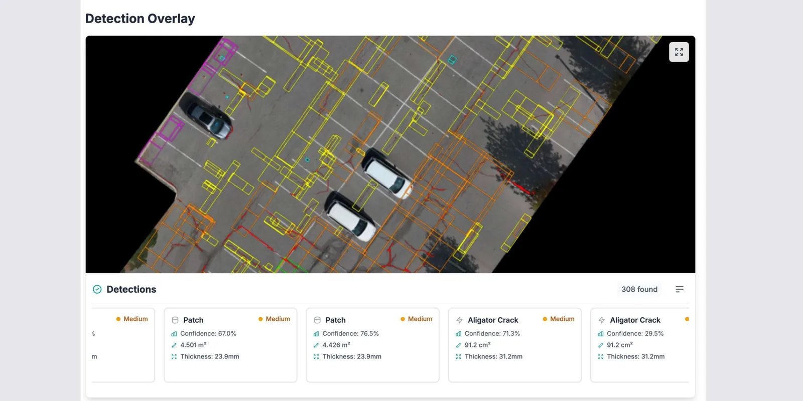
Find that out here and you re-scope the flight, rent a longer lens, or price the job honestly. Find it out after the flight and you have paid for a mobilization, a closure window, and a dataset that cannot carry a PCI score. HALO AI reads imagery from any survey-grade drone, and it cannot recover detail the camera never captured.
Tell us what you flyFlown it already? Send us the imagery.
We run a free data check and tell you within 24 hours whether the capture supports an ASTM-grade result. Sometimes the answer is that it does not, and you get that answer either way. If it qualifies, we analyze 1 ha of it at no charge. See what the report looks like first if you prefer.